
Bridg´In Mati
Standort:
Grundfläche:
Erstellt:
Collaboration:
Fachgebiet:
Professor:
Pristina, Kosovo
~ 95 ha
Wintersemester 2024/25
Hedieh Ataollahi
Internationaler Städtebau
Prof. Engel
Matican is a developing neighborhood on the outskirts of Pristina. While historically more rural, Matican has seen significant urban expansion with new apartment buildings, businesses, and roads. Due to lower property prices, it attracts people looking for more affordable housing options while still being connected to the city.
Start - Traffic - Greenspace - Infrastructure - Sense of belonging - Implementations - Masterplan
Pristina is the capital and largest city of Kosovo, serving as the political, economic, and cultural center of the country. It is located in the northeastern part of Kosovo, near the Goljak mountains, and has a population of around 200,000–300,000 people, making it the most populous city in Kosovo.
Pristina has roots dating back to Illyrian and Roman times, later becoming an important Ottoman trade and administrative center.
It houses Kosovo’s government institutions, including the Parliament, Presidency, and Prime Minister’s office. The city is home to major cultural institutions like the National Library of Kosovo, the Ethnological Museum, and the Newborn Monument, a symbol of Kosovo’s independence.
Pristina has a young population and is home to the University of Pristina, the largest university in Kosovo.
Mati 1 is one of the fastest-growing neighborhoods in Pristina, known for its new apartment complexes, modern housing, and commercial developments.
Many young professionals and families prefer Mati 1 due to its proximity to the city center, improved infrastructure, and growing amenities.


Historic Development
Matican, a district of Prishtina once a suburban area with single-family homes, is now becoming a high-density neighborhood with high-rises. This shift reflects urbanization after the Kosovo War, driven by population growth and housing demand.
Satellite images from 2003 to 2022 show Matican’s shift from single-family homes to high-rise apartments, reflecting the area's growth. Between 2003 and 2012, urban dwellings developed separately from each other, with many family houses being actively built. However, since 2012, urban dwellings have grown in size towards each other, with little regard for green spaces.
The street network has remained largely the same, leading to social issues such as parking problems, crowded streets, and a lack of public spaces. Many smaller buildings, including newer ones, have been demolished as part of this rapid urbanization.

Traffic - Link
TRAFFIC
Start - Traffic - Greenspace - Infrastructure - Sense of belonging - Implementations - Masterplan
Mapping

Vision

Potentials
Existing planning:

In the current masterplan, an extension of the existing road network is planned. Reusing these plannings, most notably the implementation of the Bypass Rruga A and E can reduce cost and plausibility of the project.
Dead-end streets:
Reduced traffic volume:
Dead-end streets discourage through traffic leading to quieter, safer streets.
Lower speeds:
Vehicles move slower in dead-end streets compared to through streets, reducing the risk of accidents.
Increased safety for pedestrians and cyclists:
Less traffic makes it safer for pedestrians and cyclists, especially in residential areas.
Better neighborhood environment:
Lower traffic volume contributes to a quieter, more livable atmosphere.
Public transport:

Regarding public transport, Mati is mostly dependent on bus travel. The existing network of Bus stops is rather dense, as one can see in the diagram map below. The busstop quantity and distances are sufficient.
There are official Bus lines organized by the municipality of Pristina.
Efforts in digitalization are to be noted. Since recently there is cooperation with the globally operating company Moovit.
All the bus schedules, bus lines and live tracking of individual busses are available in their app.
Cycling:

The most notable developed cycling paths in Mati are located alongside Rruga all aliu Kelmendi, Rruga B and in parts Muharem Fejza.
According to the Pristina Sustainable Urban Mobility Plan (SUMP) the demand for cycling infrastructure is steadily rising.
One recent reply to the rising demand is the introduction of a bike sharing system. Ten bike sharing stations have already been built throughout the city, with one located just north of Mati 1. The affordable renting process functions digitalized in an app.
Deficits
Road safety:
The SUMP reveals road safety issues across Pristina: „Research reveals that the level of injury accidents is steadily rising, almost 3 times higher in Pristina than the EU average (per 1000 population)."
→ Crossings with bad visibility
→ Missing or cars blocking sidewalk
→ no lowered curbs
→ missing road crossings
→ bike paths built dangerously

Individual Transport:
The 2023 study „Behavioral science for
Transportation behavior in
Kosovo“ conducted by IDEAS42 found out, that even tho most people (72%) think positively about using public trans-portation in pristina 86% still routinely get around by car.
→ Dependency on Cars
→ Noise and air pollution
→ Crowded parking situation
→ Congested roads
Public Transport:
„If you have to go anywhere between 3pm and 6pm save yourself from hell and go out on foot“
→ Limited to bus
→ unreliable
→ Official and private buslines
→ Busstations not apparent
Cycling:
→ Steep topography in Mati 1
→ Lacking infrastructure
→ Troublesome societal image of cyclists

Dead end streets:
Limited Connectivity:
Dead-end streets increase travel distances, leading to inefficiencies.
Higher Congestion on Main Roads:
Since vehicles cant use dead-end streets as alternate rout espacially Muharem Fajzar experiences traffic congestions.
Potential for Traffic Bottlenecks:
In some cases, cul-de-sacs can cause localized congestion at their entrances/exits, especially during peak hours.
Challenges for Emergency Services:
Emergency vehicles may take longe to respond due to limited access, or traffic congestions on the connecting main road.
Bring´in Strategy


Greenspace - Link
GREENSPACE
Start - Traffic - Greenspace - Infrastructure - Sense of belonging - Implementations - Masterplan
Mapping

Vision

Potentials
URBAN SCALE:
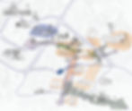
Mati lays inbetween the City centre and the Germia Park, located just east of Pristina. It is a large recreational forest area known for its beautiful natural landscapes and outdoor activities. It provides with well-maintained trails for walking, jogging, and cycling through forests and hills. It features a large outdoor pool, picnic areas, cafés, and sports fields. Families can enjoy playgrounds, while nature lovers can spot various birds and wildlife. It's a great escape from the city, offering fresh air and relaxation just a short drive from Pristina. Mati is a potential bridge. A missing link in connectivity between the city and the Nature reserve´, which is currently . The forests from the park stretch close to the edge of Mati 1.


SUBURBAN SCALE:
The surrounding neighborhoods offer some sizable public developed greenspaces and even parks that each have their own character, and utilities. For Mati residents they are not easily accessible though. Children would have to cross large main traffic axis in order to profit from the, in the greenspaces provided, infrastructure. Providing accessibility provides potential for Mati residents that can profit from and enjoy the existing greenspaces.
(1) Uni Hospital Pristina

The University Clinical Center of Kosovo is the largest medical institu-tion in the country.greenspaces in hospital environments is known to have benefits.
(2) Park Ulpiana

Ulpiana Park in Pristina is a peaceful green-space with walking paths, a fountain, and a relaxing atmosphere, making it a popular spot for locals.
(3) Uni Pristina

The campus has green spaces with newly planted trees, a small park, and a botanical garden, creating a relaxing and eco-friendly environment.
(4) Verrezat monument

The site offers panoramic views of the city. The surrounding area features a park with walking paths and green spaces.
(5) Pristina city park

The park features a variety of trees, benches, paved walking trails, a children's playground, and a café in immediate proximity to the city centre.
MATI SCALE:
Fallow land within Mati 1:

Close to the physical center of Mati 1 is sizeable area of fallow land that is in large parts owned by the government. Therefore It provides potential for design implementations on a urban scale.
Private greenspace:

Unbuilt plots, older individual houses, that are not always inhabited often have private greenspace towards the public area. These gardens and houses could be reutalized as semipublic and public greenspaces.
Existing semipublic park:

A semipublic park is located in the east part of Mati 1. While it is accessible publicly its physically shielded from the surrounding fabric by apartment komlexes. Private green areas intersect and add to its guality of stay.
Problems
URBAN & SUBURBAN SCALE:
There are quality greenspaces around Mati1. Public ones, like the areas that have been adressed under potentials, but also semipublic ones. The main Problem regarding these is the accessability, and connectivity. Especially children would have to cross main traffic axes to reach them.
MATI SCALE:
There is a general lack of developed (public) green space within mati. Greenspace exists but have no real quality. They are often trashed, or not cared for at all.
quality greenspaces are mostly private or semiprivate and pride limited to none accessability for the general public.


trashed/private greenspaces in Mati

Greenspace accessability
Bring´in Strategy


Infrastructure - Link
CIVIC INFRASTRUCTURE / TYPOLOGY
Start - Traffic - Greenspace - Infrastructure - Sense of belonging - Implementations - Masterplan
Mapping

Vision


Potentials
Convenient location:
Mati 1 is conviniently located on a urban scale. It´s densification derived from there. It offers better pricing for residential housing cormpared to the city centre, while still beeing in close proximity.
This location offers possibilities of introducing infrastructure that is tighly linked to organisations close to the city centre, like the University.
Existing Infrastructure:
Most notably the existing primary school in the south of Mati holds Potential. Its location is central and it can therefore service all Children in Mati.
If its capacities reach the limit there is no shortage of undeveloped area surrounding the school. It could easily be replanned.

Typology:
The hybrid building typology commonly found in mati 1 with office spaces or residential usage on top and commercial areas on the ground floor enhances both functionality and urban vibrancy.
The commercial spaces activate the streetscape, attracting foot traffic and creating a dynamic environment.
This mix also increases property value by diversifying revenue streams and ensuring continuous activity throughout the day.
Additionally, it promotes sustainability by reducing commuting needs and encouraging walkability. By efficiently utilizing space, this typology supports urban density and contributes to a more functional and livable city.


Problems
Urban scale:
→ Student housing not sufficient 4000 dormitory spaces for 25.000 students
→ Lack of sport facilities within rapidly growing area


Mati scale:
→ education infrastructure not sufficient:
→ no highshool in the area
→ childcare not sufficient:
→ no public kindergarden in the area
→there are very vew nightlife locations outside the city centre
→ High demand for new Civic infrastructure
→ Capycity primary school... rapid densification
→ Few public spaces for children in general
→ No nightlife locations in the area
→ No multifunctional gathering places, creative spaces, etc
→ Existing Recreational sport infrastructure mostly private


Bring´in Strategy


Sense of belonging - Link
SENSE OF BELONGING
Start - Traffic - Greenspace - Infrastructure - Sense of belonging - Implementations - Masterplan
Mapping


Learnings
Potentials:
→ Unbuilt Plots. Older individual houses for development or reuse
→ SOB overlaps are existing
→ Kids as potential to bring generations together
→ Students as target group
→ Limited budget leads to students
→ Avoiding car ownership
→ After graduation some students stay
→ Opportunities for further densification
Problems:
→ Existing overlap areas dont provide Civic infrastructure, no connecting spaces, no areas of interaction
→ Areas are devided by fallow land/streets
→ "Grey zone" inbetween
→ "Connecting With new people is hard!"

Vision

→ Give greyspaces new charater and quality of stay
→ Intervention in greyspaces
→ Interventions to catalize interaction
→ Intervention close to overlap
Bring´in Strategy


Implementations - Link
IMPLEMENTATIONS
Start - Traffic - Greenspace - Infrastructure - Sense of belonging - Implementations - Masterplan


CONCEPT DIAGRAM
Building Phases


Masterplan - Link
MASTERPLAN
Start - Traffic - Greenspace - Infrastructure - Sense of belonging - Implementations - Masterplan

DETAILS / SECTIONS


Alexander Benzler
B. Sc. Architektur
abenzler.de
015738280123
Englerstraße 7
76131 Karlsruhe